
Future Land Use Map Designation Cut Sheet
| Map Color |  |
 |
 |
 |
 |
Sample Zoning | See the relevant cut sheet and or Comprehensive Plan text |
| Description |
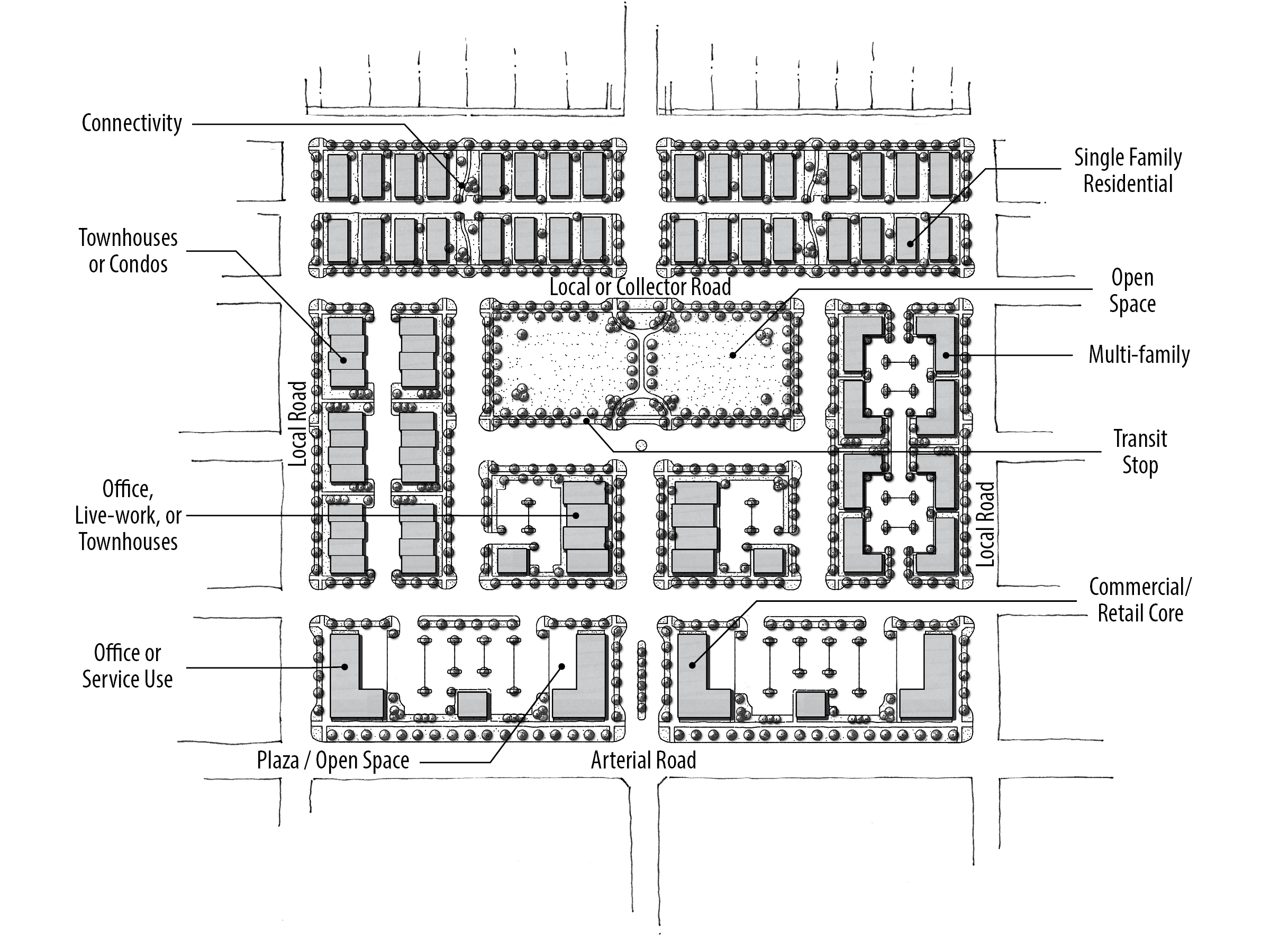
In general, the purpose of this designation is to provide for a combination of compatible land uses within a close geographic area that allows for easily accessible and convenient services for residents and workers. The intent is to promote developments that offer functional and physical integration of land uses, to create and enhance neighborhood sense of place, and to allow developers a greater degree of design and use flexibility. Uses can be mixed vertically, such as a building with retail on the ground floor and offices above, or horizontally, such as a healthcare center with a mix of doctor offices, pharmacy, beauty salon, assisted care facilities, and apartments. Mixed use areas tend to have higher floor area ratios (less area devoted to parking), open space, and interconnected vehicular and pedestrian networks. A Mixed Use designation is typically used to identify a key area within the City which is either infill in nature or situated in a highly visible or transitioning area where innovative and flexible designs are encouraged. |
| Categories |
There are five sub-categories of the Mixed Use designation that are used throughout the City: Neighborhood, Community, Regional, Interchange, and Non-Residential. This section further describes the purpose, intent, and development standards for these sub-categories. In addition, there are three sub-categories of the Mixed Use designation that are solely used in the Ten Mile Interchange Specific Area: Commercial, Residential, and Lifestyle Center. Mixed Use designations in the Ten Mile Interchange Specific Area are different than those throughout the rest of the City and are not subject to this section. For detailed descriptions of the land use designations in the Ten Mile area, go directly to the Ten Mile Interchange Specific Area Plan. For the purposes of the Mixed Use section, the City identifies five different land use types: commercial (includes retail, restaurants, etc.); office; residential; civic (includes public and quasi-public open space, parks, entertainment venues, etc.); and, industrial All development in Mixed Use areas fall within one of these five categories. Industrial uses are typically discouraged in residential mixed use areas. However, if the developer can demonstrate that industrial uses are compatible and appropriate in Mixed Use Regional (MU-R), Mixed Use Non-Residential (MU-NR), or Mixed Use Interchange (MU-I) areas, the City will consider industrial uses when proposed as part of a larger Mixed Use development. |
Mixed Use Concept Diagram
| Guidelines |
|
| Description | For additional information, see mixed use cut sheets for: |
Notes: See the References & Resources section for additional materials. When determining appropriate zoning of a property, the transition from existing, adjacent zoning designations, as well as future anticipated land use should be considered.
Questions?
Contact the Planning Division at 33 E Broadway Ave, Suite 102, Meridian ID 83642, or 208.884.5533, or https://meridiancity.org/planning/, or planning@meridiancity.org.
Last Modified: 04/01/20